This page describes how Grounding with Google Maps with Vertex AI can help to enhance your generative AI applications by providing geospatial context.
Overview
Grounding with Google Maps with Vertex AI is a service that connects Gemini models with geospatial data from Google Maps. Google Maps has access to information on millions of locations, including businesses, landmarks, and points of interest. This data gives you access to information on over 250 million places that can be used to ground your model's responses, enabling your AI applications and agents to provide local data and geospatial context.
You can also enable concurrent grounding with Google Maps, Google Search, and grounding with your data sources.
Uses of Grounding with Google Maps
You can use Grounding with Google Maps for various applications, such as:
- Conversational assistants that can answer questions about nearby places, such as "Where's the nearest place to get an Italian espresso?"
- Personalized descriptions and community insights, such as"Can you tell me more about family-friendly restaurants that are within a walkable distance?"
- Summaries of areas around specific locations, such as an EV charging station or a hotel.
This can be beneficial for use cases in real estate, travel, mobility, and social-media apps.
Supported models
This section lists the models that support Grounding with Google Maps.
- Gemini 2.5 Flash (Preview)
- Gemini 2.5 Flash-Lite (Preview)
- Gemini 2.5 Flash-Lite
- Gemini 2.5 Flash with Live API native audio (Preview)
- Gemini 2.0 Flash with Live API (Preview)
- Gemini 2.5 Pro
- Gemini 2.5 Flash
- Gemini 2.0 Flash
For more information about the Gemini models, see Gemini models.
Use Grounding with Google Maps to ground your model's responses
This code sample demonstrates how to use Grounding with Google Maps to ground your model's responses.
Search results can be customized for a specific geographic location by using the latitude and longitude coordinates. For more information, see the Grounding API.
Console
To use Grounding with Google Maps with Vertex AI, follow these steps:
In the Google Cloud console, go to the Vertex AI Studio page.
In the Tools section, click Grounding: Google. A configuration pane appears.
To use Google Maps, click Google Maps toggle.
Click Apply.
Enter your prompt in the field, and click Submit. Your prompt responses ground to Google Maps.
Python
Install
pip install --upgrade google-genai
To learn more, see the SDK reference documentation.
Set environment variables to use the Gen AI SDK with Vertex AI:
# Replace the `GOOGLE_CLOUD_PROJECT` and `GOOGLE_CLOUD_LOCATION` values
# with appropriate values for your project.
export GOOGLE_CLOUD_PROJECT=GOOGLE_CLOUD_PROJECT
export GOOGLE_CLOUD_LOCATION=global
export GOOGLE_GENAI_USE_VERTEXAI=True
from google import genai
from google.genai.types import (
    GenerateContentConfig,
    GoogleMaps,
    HttpOptions,
    Tool,
)

client = genai.Client(http_options=HttpOptions(api_version="v1"))

response = client.models.generate_content(
    model="gemini-2.5-flash",
    contents="Where can I get the best espresso near me?",
    config=GenerateContentConfig(
        tools=[
            # Use Google Maps Tool
            Tool(google_maps=GoogleMaps(
              enable_widget=False # Optional: return Maps widget token
            ))
        ],
        tool_config=types.ToolConfig(
            retrieval_config = types.RetrievalConfig(
                lat_lng = types.LatLng( # Pass geo coordinates for location-aware grounding
                    latitude=40.7128,
                    longitude=-74.006
                ),
                language_code = "en_US", # Optional: localize Maps results
            ),
        ),
    ),
)

print(response.text)
# Example response:
# 'Here are some of the top-rated places to get espresso near you: ...'
REST
Before using any of the request data, make the following replacements:
- LOCATION: The region to process the request. To use the global endpoint, exclude the location from the endpoint name and configure the location of the resource to global.
- PROJECT_ID: Your project ID.
- MODEL_ID: The model ID of the multimodal model.
- PROMPT: The prompt to send to the model.
- LATITUDE: The latitude of the location. For example, a latitude of
37.7749represents San Francisco. You can obtain latitude and longitude coordinates using services like Google Maps or other geocoding tools. - LONGITUDE: The longitude of the location. For example, a longitude of
-122.4194represents San Francisco. - ENABLE_WIDGET: Whether to return a token and enable the Google Maps widget (default is
false).
HTTP method and URL:
POST https://LOCATION-aiplatform.googleapis.com/v1beta1/projects/PROJECT_ID/locations/LOCATION/publishers/google/models/MODEL_ID:generateContent
Request JSON body:
{
  "contents": [{
    "role": "user",
    "parts": [{
      "text": "PROMPT"
    }]
  }],
  "tools": [{
    "googleMaps": {
      "enableWidget": "ENABLE_WIDGET"
    }
  }],
  "toolConfig": {
    "retrievalConfig": {
      "latLng": {
        "latitude": LATITUDE,
        "longitude": LONGITUDE
      },
      "languageCode": "en_US"
    }
  },
  "model": "projects/PROJECT_ID/locations/LOCATION/publishers/google/models/MODEL_ID"
}
To send your request, expand one of these options:
You should receive a JSON response similar to the following:
{
  "candidates": [
    {
      "content": {
        "role": "model",
        "parts": [
          {
            "text": "\"The Italian Place\" in Alexandria, VA, is good for children and offers takeout. It has a rating of 4.2 stars based on 411 reviews."
          }
        ]
      },
      "finishReason": "STOP",
      "groundingMetadata": {
        "groundingChunks": [
          {
            "maps": {
              "uri": "https://maps.google.com/?cid=9001322937822692826",
              "title": "The Italian Place",
              "placeId": "places/ChIJOTRDf_qwt4kR2kV_WYUf63w"
            }
          },
          {
            "maps": {
              "uri": "https://maps.google.com/?cid=9001322937822692826",
              "title": "Hank's Pasta Bar",
              "placeId": "places/MMVtPzn9FGcevML89",
              "placeAnswerSources": {
                "reviewSnippets": [
                  {
                    "id": "places/ChIJOTRDf_qwt4kR2kV_WYUf63w",
                    "title": "Google Maps Review",
                    "uri": "https://maps.google.com/?cid=9001322937822692826"
                  },
                ]
              }
            }
          },
          ...
        ],
        "groundingSupports": [
          {
            "segment": {
              "endIndex": 79,
              "text": "\"The Italian Place\" in Alexandria, VA, is good for children and offers takeout."
            },
            "groundingChunkIndices": [
              0
            ]
          },
        ],
        "googleMapsWidgetContextToken": "widgetcontent/..."
      }
    }
  ],
  ...
}
Place properties
This section lists place properties that are used to describe locations and used by Grounding with Google Maps to generate responses. These properties are used to determine the types of questions that Grounding with Google Maps can answer.
Sample place properties
This list provides an alphabetized sampling of properties about places that can be used by your model to generate responses.
- Address
- Curbside pickup
- Debit card
- Distance
- Free parking lot
- Live music
- Menu for children
- Opening hours
- Payment options (such as cash or credit card)
- Place answer
- Pet friendly
- Serves beer
- Serves vegetarian food
- Wheelchair accessible
- Wifi
Place answers are a response from Grounding with Google Maps based on information derived from user reviews.
Examples of using place properties
The following examples use place properties in questions about different types of places. Grounding with Google Maps uses the properties to understand your intent and then provides relevant answers based on the data associated with places in Google Maps.
Plan a family dinner: You might ask, Is "The Italian Place" good for children, and do they offer takeout? What is their rating?
Answers to these questions help you to determine if a restaurant is suitable for a family and if the restaurant offers a convenient service.
Check accessibility for a friend: You might ask, I need a restaurant that has a wheelchair accessible entrance.
A response to this prompt might help you to determine if the location meets specific accessibility needs.
Find a location for a late-night snack: You might ask, Is "Burger Joint" open now? Do they serve dinner? What are their opening hours for Friday?
Answers to these questions help you to find an open establishment serving a specific meal during a particular time.
Meet a client for coffee: You might ask, Does "Cafe Central" have Wifi? Do they serve coffee? What is their price level, and do they accept credit cards?
Answers to these questions help you to assess the suitability of a cafe for a business meeting based on amenities, offerings, and payment options.
Information in the Google Maps Grounded Results might differ from actual conditions of the road.
Understand your response
Google Maps sources are returned in groundingMetadata within
groundingChunks. Sources are returned for places and for user reviews,
which have been used to help generate the Google Maps Grounded Result.
This code sample demonstrates a place source and a place answer source in the response:
"groundingChunks": [
  {
    "maps": {
      "uri": "{Link to Maps Content}",
      "title": "{Name of Maps Place}",
      "placeId": "{Place ID}",
      "placeAnswerSources": {
        "reviewSnippets" : [
          {
            "reviewId": "{Review ID}",
            "googleMapsUri": "{Link to Maps Content}",
            "title": "{Title of review}"
          }
        ]
      }
    },
  }
],
Service usage requirements
This section describes the service usage requirements for Grounding with Google Maps.
Inform the user about the use of Google Maps sources
With each Google Maps Grounded Result, you'll receive sources in
groundingChunks that support each response. The following metadata is also
returned:
- source uri
- title
- ID
When presenting results from Grounding with Google Maps with Vertex AI, you must specify the associated Google Maps sources, and inform your users of the following:
- The Google Maps sources must immediately follow the generated content that the sources support. This generated content is also referred to as Google Maps Grounded Result.
- The Google Maps sources must be viewable within one user interaction.
Display Google Maps sources with Google Maps links
For each source in groundingChunks and in
grounding_chunks.maps.placeAnswerSources.reviewSnippets, a link preview must
be generated following these requirements:
- Attribute each source to Google Maps following the Google Maps text attribution guidelines.
- Display the source title provided in the response.
- Link to the source using the
uriorgoogleMapsUrifrom the response.
These images show the minimum requirements for displaying the sources and Google Maps links.
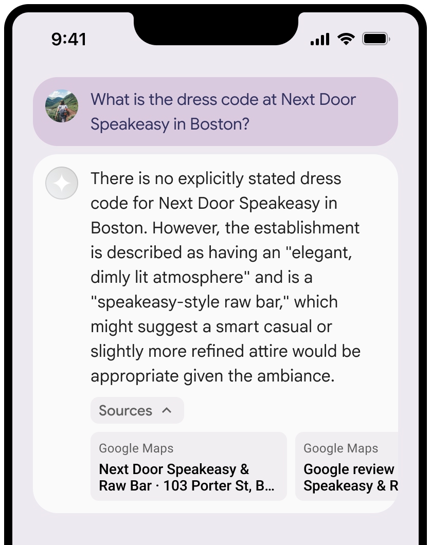
You can collapse the view of the sources.
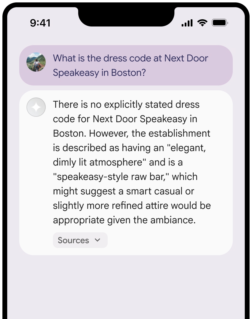
Optional: Enhance the link preview with additional content, such as:
- A Google Maps favicon is inserted before the Google Maps text attribution.
- A photo from the source URL (
og:image).
For more information about some of our Google Maps data providers and their license terms, see the Google Maps and Google Earth legal notices.
Google Maps text attribution guidelines
When you attribute sources to Google Maps in text, follow these guidelines:
- Don't modify the text Google Maps in any way:
- Don't change the capitalization of Google Maps.
- Don't wrap Google Maps onto multiple lines.
- Don't localize Google Maps into another language.
- Prevent browsers from translating Google Maps by using the HTML
attribute
translate="no".
- Style Google Maps text as described in the following table:
| Property | Style |
|---|---|
| Font family | Roboto. Loading the font is optional. |
| Fallback font family | Any sans serif body font already used in your product or "Sans-Serif" to invoke the default system font |
| Font style | Normal |
| Font weight | 400 |
| Font color | White, black (#1F1F1F), or gray (#5E5E5E). Maintain accessible (4.5:1) contrast against the background. |
| Font size | Minimum font size: 12sp Maximum font size: 16sp To learn about sp, see Font size units on the Material Design website. |
| Letter spacing | Normal |
Example CSS
The following CSS renders Google Maps with the appropriate typographic style and color on a white or light background.
@import url('https://fonts.googleapis.com/css2?family=Roboto&display=swap');

.GMP-attribution {
font-family: Roboto, Sans-Serif;
font-style: normal;
font-weight: 400;
font-size: 1rem;
letter-spacing: normal;
white-space: nowrap;
color: #5e5e5e;
}
Context token, place ID, and review ID
The Google Maps data includes context token, place ID, and review ID. You might cache, store, and export the following response data:
googleMapsWidgetContextTokenplaceIdreviewId
The restrictions against caching in the Grounding with Google Maps Terms don't apply.
Prohibited Territory
Grounding with Google Maps has restrictions for certain content and activities to maintain a safe and reliable platform. Customer will not distribute or market a Customer Application that offers Grounding with Google Maps in a Prohibited Territory. The current Prohibited Territories are:
- China
- Crimea
- Cuba
- Donetsk People's Republic
- Iran
- Luhansk People's Republic
- North Korea
- Syria
- Vietnam
This list may be updated from time to time.
Optional: Google Maps contextual widget
The contextual widget is a Google Maps Pre-GA Offering that's a visual
container used to support or supplement other Google Maps content. The
Google Maps contextual widget lets you integrate Grounding with Google Maps
into your applications to create a conversational LLM-powered chat experience.
The contextual widget is rendered using the context token,
googleMapsWidgetContextToken, which is returned in the
Vertex AI API response and can be used to render visual content.
The contextual widget serves different functions depending on your scenario:
It displays user reviews and photos, which is user-generated content (UGC), in the scenario where Google Maps prompting is used for answer generation.
It helps to enrich results with map visualizations and data when Vertex AI generates just a text response.
For more information on the contextual widget, see Maps grounding widget.
Render the Google Maps contextual widget
To render and use the Google Maps contextual widget, use the alpha version of the Google Maps JavaScript API on the page that displays the widget. For more information, see Load the Maps JavaScript API.
The following code samples demonstrate how to use a contextual widget:
Create a contextual widget.
  <body>
   <gmp-place-contextual id="widget"></gmp-place-contextual>
  </body>
In any response that is grounded with Google Maps, there's a corresponding
googleMapsWidgetContextTokenthat's used to render the contextual widget and placed in close proximity to the generated response.To update the context token, set the
widget.contextToken property."googleMapsWidgetContextToken": "widgetcontent/AcBXPQdpWQWbap9H-OH8sEKmOXxmEKAYvff0tvthhneMQC3VrqWCjpnPBl4-Id98FGiA_S_t8aeAeJj0T6JkWFX56Bil8oBSR0W8JH3C_RSYLbTjxKdpxc9yNn6JcZTtolIRZon9xi6WpNGuSyjcIxWu2S0hwpasNOpUlWrG1RxVCB4WD1fsz_pwR236mG36lMxevXTQ_JnfdYNuQwQ4Lc3vn...<snip>... Ts5VJE_b3IC5eE_6wez0nh61r7foTUZpP7BXMwxR-7Wyfcj6x1v6mIWsFGr1o0p_HSAMNqWPg-aFVnkPLhAkOR6MaNZOfezTva-gxHlu7z_haFvYxcUE1qfNVQ",function updateWidget(contextToken) { let widget = document.querySelector('#widget'); widget.contextToken = contextToken; }Optional: Specify the list layout. Valid values include the following:
- Compact layout:
<gmp-place-contextual-list-config layout="compact"> - Vertical layout:
<gmp-place-contextual-list-config layout="vertical">
This code sample demonstrates changing the list layout to a compact layout.
<gmp-place-contextual id="widget"> <gmp-place-contextual-list-config layout="compact"> </gmp-place-contextual-list-config> </gmp-place-contextual>- Compact layout:
Optional: Change the map mode. Valid values include the following:
- 2D roadmap map:
map-mode="roadmap" - 3D hybrid map:
map-mode="hybrid" - No map:
map-mode="none"
This code sample demonstrates changing the map mode to a 2D map.
<gmp-place-contextual id="widget"> <gmp-place-contextual-list-config map-mode="roadmap"> </gmp-place-contextual-list-config> </gmp-place-contextual>- 2D roadmap map:
What's next
- To learn more about how to ground Gemini models to your data, see Grounding with your data.
- To learn more about responsible AI best practices and Vertex AI's safety filters, see Responsible AI.